
Snippets from the life of Martha Sarah Ellis.

"This forms a somewhat autonomous part of Peckham, its redeeming feature being the absence of high dwellings. Except in one or two darks little corners, peoples may always be conscious of the sky, and have plenty of light.
Of local employment there is little to any. A certain number of women must find work in the local laundries, and a few small places on the canal banks may give employment to a few of the people living here, as in every part of Peckham and Camberwell, except in the immediate neighbourhood of the Gas-works, find their employment in more central London. ... There is only one new street, Pennick St., of the prevailing local type of two-story houses, in the district as a whole; there has been practically no rebuilding. And the local class of occupant appears to have changed as little as the structure, during the decade."[1]
The Ellis family home would have been typical of others in the area, a two-story dwelling as described by Booth. Terrace homes for the period usually had a front room with a window, and a door onto the road. Like the other traders, Martha’s father would have operated his boot-shop from the front room. There would have also been a back room and a small scullery/kitchen. No bathroom in those days, just an outside privy/toilet. There would have also been one or two rooms upstairs that the family would have shared.
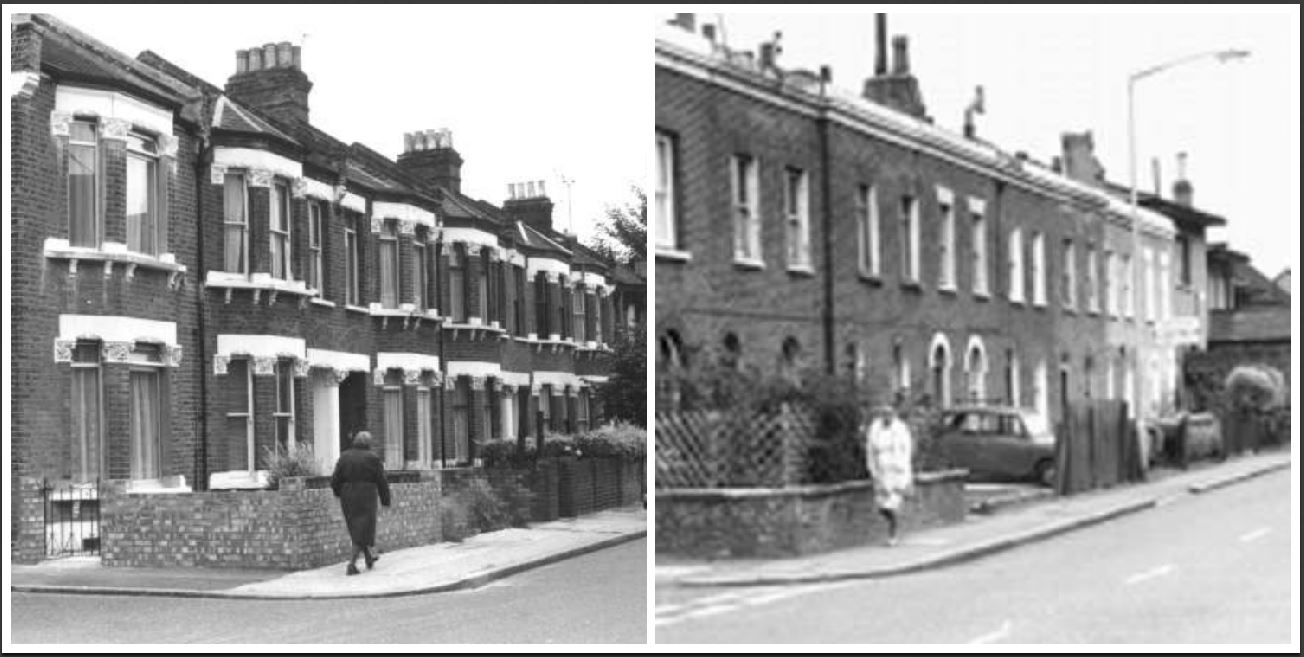 |
| Figure 1 The terraces on the left were built early in the Victorian Era whereas the terraces on the right were built in the 1840s on Wells st just around the corner for further details see below |
It’s hard to imagine the living conditions of yester year. Space would have been tight, privacy would have been limited, and the upkeep of such a small space would have been quite difficult with so many people. The bulk of the work would have fallen on the women of the household.
Charles Booth's London “poverty maps were created between 1886 and 1903, as part of Charles Booth's ground-breaking study into the lives of ordinary Londoners.” [Craig, Zoe. 2016. "Charles Booth's Victorian Poverty Map Is Now Online". Londonist. Accessed March 11 2017. http://londonist.com/london/history/charles-booths-poverty-map-is-now-interactive.]
To Read more about Martha's life for articles previously posted for the A to Z Challenges click the Letters below:-
A B C D E F G H I J K L M N O P Q R S T U V W X Y Z
Image Credits
“Wells Way, Camberwell, 1980 | London Borough of Southwark | Ideal Homes.” IDEAL HOMES:A HISTORY OF SOUTH-EAST LONDON SUBURBS. Accessed March 11, 2017. http://www.ideal-homes.org.uk/southwark/assets/galleries/camberwell/wells-way.
Sources
[1] British Library of Political and Economic Science, Ernest Aves' Notebook: Police District 35 [Kennington (2nd) and Brixton], District 42 [St George Camberwell], District 43 [Camberwell], District 44 [Peckham], District 45 [Deptford], District 47 [Sydenham, Lewisham, Eltham and Lee], page 81, https://booth.lse.ac.uk/notebooks/b373#?cv=43&c=0&m=0&s=0&z=-42.2009%2C0%2C2498.4018%2C1486. Accessed 23 February 2017
I've never heard of poverty maps before, but they sound interesting. And I agree, I can't imagine what it would have been like to live in such crowded conditions.
ReplyDeleteVisit my "B" post here: https://lydiahowe.com/2017/04/03/b-is-for-backstory-atozchallenge/
Thanks for dropping by Aidyl
DeleteI'm also blogging on family history/genealogy for A to Z. These seem to be a wonderful resource. In the U.S. we use fire maps for similar information. Great to have those photos! http://mollyscanopy.com/
ReplyDeleteThanks Molly, it was great to find the photos online, it really helped me get an understanding of what things must have been like and I agree maps are a great resource.
DeleteI had a cousin who moved to Canada (Windsor) from Italy in the 1950's. He found a building where he had his barbershop downstairs and the family lived upstairs. And the upstairs was no larger than the shop. His business thrived and eventually they built a real home. Much the same goes on here today with immigrants trying to make a new life.
ReplyDeleteHi, It is hard to imagine what it was like to live in London in the late 1800s. I am inclined to forget about how smoky & smoggy it would be from all the fires. Fran
ReplyDeleteA to Z Theme: Sharing Family History via #GenealogyPhotoADay By Fran from at the TravelGenee Blog
thanks is one thing that is hard to find in our ancestors document trail is a sense of place, the smells, the sites and sounds. Booths maps do help to fill in some of the gaps.
DeleteThanks for dropping by.